

Timeline of the 2025 Texas Floods
| Date | Key Events |
| July 3 | NWS issues flood watch for Central Texas predicting 5-7 inches of rain |
| July 4 (Early AM) | Storms rapidly intensify; 12+ inches of rain fall in parts of Hill Country |
| July 4 (4:03 AM) | Flash flood emergency issued; Guadalupe River surges 26 ft in < 1 hour |
| July 4 (4:35 AM) | USGS flood gauge fails near Camp Mystic |
| July 4 (Morning) | Camp Mystic overwhelmed; 27 lives lost |
| July 5 | Over 850 rescues conducted; national response initiated |
| July 6 | NFL & Texas teams donate $1.5 million to recovery efforts |
Climate Catastrophe
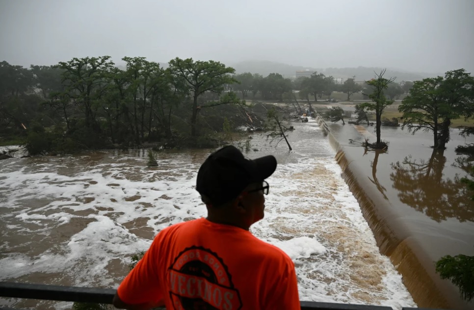
The flooding in Texas Hill Country in early July 2025 was devastating. 104 people lost their lives, 27 of them campers and staff at Camp Mystic in Kerr County. This isn’t just a story of heavy rain—it’s a symptom of climate extremes.
The floodwaters were a deadly combination: remnants of Tropical Storm Barry merged with a stalled front and dumped up to 21 inches of rain in some areas like Bertram. Central Texas is known as “Flash Flood Alley” because of its limestone hills and clay soils that funnel rain into rivers.
How Climate Change Caused the Texas Floods
Climate scientist Daniel Swain says for every degree Fahrenheit of global warming, the atmosphere can hold 3-4% more water vapor. With 2023 being 2.32°F above the 20th century average, Texas has seen a 5-15% increase in extreme one-day rainfall events.
The result? A supercharged water cycle. Posts by meteorologists like @shelwinkleywx on X show climate change is amplifying rain bursts, especially in areas like Central Texas.
Why the 2025 Texas Floods Were So Deadly
- Geographic Vulnerability
Hill Country’s steep terrain, thin soils, and low absorption rates make it prone to flash floods. When intense rain falls, water races downhill instead of soaking in, overwhelming rivers like the Guadalupe—which surged 26 feet in under an hour.
- Storm System Mechanics
The storm system created a “training” effect: multiple thunderstorms dumping rain over the same areas for hours. According to @NWSHouston, this made floodwaters rise with stunning speed. The Guadalupe, Medina, and Llano Rivers became destructive torrents.
- Lack of Real-Time Warning
Despite early forecasts, actual rainfall far exceeded predictions. Kerr County lacked a $1 million flood warning system proposed in 2017, citing budget concerns. A USGS gauge failure at 4:35 a.m. on July 4 further impaired early alerts, leaving communities blind to the coming surge.
- Holiday Crowds and Exposure
The disaster struck during the July 4 weekend, when thousands of tourists and campers filled flood-prone zones. Camp Mystic hosted 750 campers. Despite an NWS warning issued hours earlier, no evacuation occurred, magnifying the loss of life.
Texas Floods: Historical Patterns & Shifting Trends
Texas has endured several catastrophic floods over the decades, but the 2025 event marks a turning point in intensity and death toll. Here’s how it compares:
| Year | Event | Death Toll | Rainfall | Damage |
| 1921 | Thrall Flood | 215+ | 38″ in 18 hrs | N/A |
| 1998 | Guadalupe River Flood | 31 | 20″+ | $750M |
| 2001 | TS Allison | 41 | 40″+ | $5.2B |
| 2017 | Hurricane Harvey | 107 | 60″+ | $125B |
| 2025 | Hill Country Floods | 104 | 21″ | TBD |
According to NOAA, the frequency of extreme rain events in Texas has increased steadily since the 1980s. With climate projections showing a 20-30% rise in single-day downpours by 2036, these floods are no longer “once-in-a-century.”
What Texas Communities Are Doing Differently Now
In the aftermath, communities are beginning to act:
- Kerr County has now approved a flood warning system using regional and federal grants.
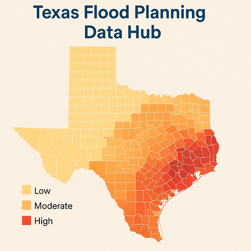
- Texas Water Development Board is expanding its Flood Planning Data Hub and launching rural training sessions.
- Local schools in Hunt and Ingram are adding flood drills and education weeks.
- San Antonio and others are investing in bioswales and permeable pavement to absorb runoff.
These efforts mark a shift from reactive to proactive flood planning—but momentum must continue.
Expert Voices: What Scientists and Rescuers Say
“This was a perfect storm, but one we’ve been warning about for years,” says Daniel Swain, climate scientist at UCLA.
“We had under 10 minutes between the emergency alert and the water reaching cabins,” said a Kerr County firefighter, describing the chaos at Camp Mystic.
“We need flood gauges that don’t fail, and we need them now,” says a TWDB hydrologist, emphasizing rural infrastructure gaps.
These voices reflect the urgency of modernizing forecasting and local response systems.
What the Texas Floods Reveal About Nationwide Risk
This wasn’t just a Texas tragedy. Across the U.S., outdated maps, limited rural funding, and climate-driven events are converging into a national flood risk crisis.
- Appalachia, Ozarks, and Central California face similar terrain-based flash flood dangers.
- FEMA has a backlog of over 50% outdated floodplain maps.
- Low-income communities are often least equipped to respond, lacking insurance or early warning systems.
- FEMA Flood Map Center allows anyone to check their address for flood risk. Visit here
The lesson: Texas is the bellwether. What happened in Hill Country could happen elsewhere unless action scales nationwide.
Systemic Failures in Preparedness
Texas has been flood-prone for years, but investment in rural warning systems is spotty. Kerr County’s decision to not invest in a flood alert system in 2017 is glaring. At 1.5% of the county’s $67 million budget, it was rejected and left communities unprotected.
Forecasting errors made it worse. The NWS issued a flood watch on July 3 for 5-7 inches of rain. But in Bertram, it tripled. As meteorologist Jonathan Porter from AccuWeather said, proactive evacuations could have saved lives.
This is similar to Tropical Storm Allison (2001) and Hurricane Harvey (2017) where outdated floodplain maps and poor communication caused unnecessary suffering.
The Cost of Federal Disinvestment
Federal cuts to NOAA and NWS have people worried. Under the Trump administration, 600 meteorologist positions were cut and the U.S. Global Change Research Program was eliminated. Critics, including former NOAA official Michael Morgan, say this will hinder future preparedness.
Some say there were enough staff during the 2025 floods, but without high-resolution models and updated rainfall data, forecast accuracy was severely limited.
Environmental and Social Impacts
Widespread Ecological Damage
Trees were uprooted, roads were washed away and water was contaminated with debris, fuel and household chemicals. Aquatic life and downstream reservoirs may be damaged for years to come. NOAA’s outdated rainfall records have skewed risk calculations in floodplain planning as the Texas Water Development Board pointed out.
Human Toll and Economic Loss
Beyond the 104 fatalities, emotional trauma runs deep—especially at Camp Mystic where lives and legacy were lost. Damage is likely over $5.2 billion and surpasses Tropical Storm Allison. Recovery is ongoing with intermittent storms and over 850 rescues already logged.
Visual Risk Map: Texas Flood Planning Data Hub
A Call to Action: Preventing Future Texas Floods
The 2025 floods are a wake-up call. Here’s what must happen now:
- Cut Fossil Fuel Emissions
Climate change is not far away. Transitioning to clean energy and enforcing stricter emissions standards must be the top priority.
- Invest in Rural Flood Infrastructure
Texas needs flood warning systems, updated floodplain maps and resilient construction in flood prone areas. Tools like TWDB’s Floodplain Quilt and IDRT Risk Tool must be fully funded.
- Reverse Cuts to Forecasting Agencies
Restore NOAA and NWS staffing and rebuild climate databases. Accurate modeling depends on it.
- Foster Community Preparedness
Texas must create a culture of safety: timely evacuations, public flood drills and education campaigns for locals and tourists.
Preparedness Checklist for Flood Prone Texans
- Sign up for NWS alerts and local emergency texts
- Avoid low water crossings during rain forecasts
- Keep a “go bag” with documents, medicine, water, flashlight
- Know the location of nearby flood shelters
- Don’t wait for official evacuation orders if in danger zone
FAQs About the 2025 Texas Floods
Q: What caused the 2025 Texas floods?
A: A stalled storm system combined with remnants of Tropical Storm Barry brought intense rain which overwhelmed rivers in Central Texas, especially the Guadalupe.
Q: Where was the worst flooding?
A: Kerr County and surrounding Hill Country areas like Bertram, Hunt and Ingram were the hardest hit.
Q: How does climate change relate to this event?
A: Warmer temps allow more moisture in the air, more extreme rain. Texas has seen 5-15% increase in single day heavy rain events.
Q: Was this preventable?
A: While natural rain can’t be stopped, better forecasting, warning systems and proactive evacuations could have saved lives.
Conclusion: No More Half Measures
The 2025 Texas floods are a harsh reminder that nature and policy collide with deadly consequences. From the heartbreak at Camp Mystic to the policy holes in disaster readiness, it’s time for change.Now is the time—clean energy, flood infrastructure, federal science and community preparedness. Not again.